Smiths Falls Area Out of Town Cycling Routes
About the map
This is a map of suggested routes for visitors or residents to explore the area immediately surrounding Smiths Falls, Ontario. You could also use the the map to come up with your own variations. Each route is less than an hour and a half, so you needn’t be a serious cyclist to try them out.
Be safe
Cyclists should use these routes at their own risk. Please wear a helmet and follow all safety rules. Be prepared for traffic on Highways 15, 29, 43 and Roger Stevens Drive, and consider avoiding them altogether if there are inexperienced riders in your group. Review safe cycling guidelines with everyone in your group before setting out.
Have fun!
 |
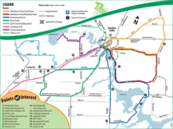 |
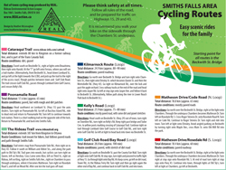
Most routes are described as departing and returning to the Beckwith Street Bridge in the centre of Smiths Falls. Five routes are loops, and the Poonamalie Route is an “out and back route”.
The remaining two routes are the Cataraqui and Rideau Trails. We included these trails because we have discovered many residents don’t understand where they pass through town. The Cataraqui Trail is a shared use trail with its end point in Smiths Falls, so it can be followed south as far as 80 km. The Rideau Trail was developed for hikers, but through Smiths Falls it mostly follows road and paths than can be biked. REAL encourages you to find out more about these trails through their websites.
Printed version available
This map was designed in an 8 1/2 x 11 inch format so it could be printed on a home printer. The Town of Smiths Falls has published a cycling map which features in town routes on one side and these out of town scenic routes on the other. Look for it where you find printed tourist information in the region , consult the Town of Smiths Falls website, or see the map displayed at Lower Reach Park.
Comments
We welcome comments and suggestions for future editions of the map. Maybe you have a favourite route you think others would enjoy. Send comments.
Who was involved
 This map was the work of many REAL volunteers. Thanks to Judy Snider for cycling and measuring the routes. A Katimavik participant and summer student Heather Davidson were involved in the early stages. Volunteers Kirk Everett, Beth Graham, Cathryn and Dan Davidson and Barb Hicks all contributed. Special thanks to Heather McLenaghan for her patient design work.
Why is REAL doing a cycling map?
REAL formed a Climate Change Action Team back in early 2007 in response to screenings of the film “An Inconvenient Truth” . The group kept coming back to the need for better transportation options, including walking and biking. While these routes are meant for recreational purposes, we feel that is one step in creating a culture of cycling. Once more people become interested in biking they may make the consider cycling for getting around for work, school or errands.
REAL welcomes active forms of transportation (walking and biking) for several reasons. Active transportation:
- produces fewer greenhouse gases
- conserves fossil fuels
- is healthier for the participants
- contributes to a sense of community
Other Biking Resources
 You may wish to explore other biking possibilities in our area:
- Merrickville Cycling group has a map of three cycling routes: a short trip through the village, Merrickville-Burritts Rapids route (17.6 km), Merrickville-Kilmarnock-Eastons Corners (29.6 km). in print only
- Perth and District – several downloadable routes
- Frontenac Arch – learn about routes in and around Brockville, Prescott, Kingston, Sydenham, Westport, Smith Falls, Merrickville and Kemptville.
- See Lanark County Tourism site.
- See Ontario by Bike for links to other Lanark County routes.